State of the Art Software
-
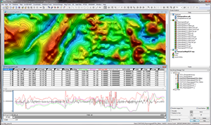
Oasis Montaj - a fully integrated platform for data management, processing, analysis, and mapping of geophysical and geologic data.
-
Montaj MAGMAP Filtering - a comprehensive set of geophysical and mathematical 2D-FFT filters for the enhancement of gridded datasets.
-
Montaj Geophysics - a suite of 1D and 1D FFT filters and statistical tools for working with large volume geophysical data.
-
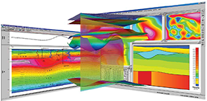
Montaj Grav/Mag Interpretation - a processing, analysis and visualization system for 3D inversion of potential field data. Depth estimation techniques include Euler 3D Convolution and Source Parameter Imaging(SPI).
-
GM-SYS 3D Modeling- an interactive 3D gravity and magnetic modeling workflow for surface-oriented models. Designed to build layered 3D models within Oasis Montaj that accurately depict the variation and irregularity of subsurface structures and calculate the models' gravity and magnetic responses.
-
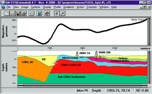
GM-SYS Profile Modeling - an extension within Oasis Montaj for calculating the gravity and magnetic response from a geologic cross-section model. The interactive platform provides the ability to modify the model structure and parameters to fit observed data.
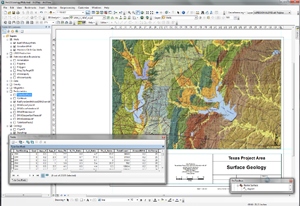
- ArcGIS Desktop - powerful GIS software for data management, spatial analysis, mapping and visualization of both vector and raster GIS formats.
-
3D Analyst Extension - provides advanced visualization, analysis, and surface tools for vector and raster GIS data in a three dimensional perspective.
-
Publisher Extension - provides custom interactive maps and data to clients through ArcReader, a free viewer application.
Thompson Solutions LLC
7845 S. Kearney Court
Centennial, CO 80112
303-887-5398
![]()